

[fusion_builder_container background_color=”” background_image=”” background_parallax=”none” enable_mobile=”no” parallax_speed=”0.3″ background_repeat=”no-repeat” background_position=”left top” video_url=”” video_aspect_ratio=”16:9″ video_webm=”” video_mp4=”” video_ogv=”” video_preview_image=”” overlay_color=”” video_mute=”yes” video_loop=”yes” fade=”no” border_size=”0px” border_color=”” border_style=”solid” padding_top=”5px” padding_bottom=”5″ padding_left=”” padding_right=”” hundred_percent=”no” equal_height_columns=”no” hide_on_mobile=”no” menu_anchor=”” class=”” id=””][fusion_builder_row][fusion_builder_column type=”1_1″ layout=”1_1″ last=”yes” spacing=”yes” center_content=”no” hide_on_mobile=”no” background_color=”” background_image=”” background_repeat=”no-repeat” background_position=”left top” hover_type=”none” link=”” border_position=”all” border_size=”0px” border_color=”” border_style=”solid” padding_top=”” padding_right=”” padding_bottom=”” padding_left=”” margin_top=”” margin_bottom=”” animation_type=”slide” animation_direction=”up” animation_speed=”1″ animation_offset=”” class=”” id=”” min_height=””][fusion_flip_boxes columns=”4″ class=”” id=””][fusion_flip_box title_front=”GIS Starting Points” title_back=”GIS Starting Points” text_front=”Learn the basics today!” background_color_front=”” title_front_color=”” text_front_color=”” background_color_back=”” title_back_color=”” text_back_color=”” border_size=”0px” border_color=”” border_radius=”4px” icon=”fa-file-text” icon_color=”” circle=”yes” circle_color=”#723477″ circle_border_color=”” icon_rotate=”” icon_spin=”no” image=”” image_max_width=”35″ image_height=”35″ animation_type=”fade” animation_direction=”up” animation_speed=”0.1″ animation_offset=””]
Learn the Basics
Getting Started for
Executives | Developers | IT
[/fusion_flip_box][fusion_flip_box title_front=”Stay Current” title_back=”Stay Current” text_front=”With the new technologies and services.” background_color_front=”” title_front_color=”” text_front_color=”” background_color_back=”” title_back_color=”” text_back_color=”” border_size=”1px” border_color=”” border_radius=”4px” icon=”fa-check” icon_color=”” circle=”yes” circle_color=”#723477″ circle_border_color=”” icon_rotate=”” icon_spin=”no” image=”” image_max_width=”35″ image_height=”35″ animation_type=”fade” animation_direction=”up” animation_speed=”0.1″ animation_offset=””]
[/fusion_flip_box][fusion_flip_box title_front=”Create & Share Maps” title_back=”Create & Share Maps” text_front=”Tell Your Story with Maps” background_color_front=”” title_front_color=”” text_front_color=”” background_color_back=”” title_back_color=”” text_back_color=”” border_size=”1px” border_color=”” border_radius=”4px” icon=”fa-map” icon_color=”” circle=”yes” circle_color=”#723477″ circle_border_color=”” icon_rotate=”” icon_spin=”no” image=”” image_max_width=”35″ image_height=”35″ animation_type=”fade” animation_direction=”up” animation_speed=”0.1″ animation_offset=””]
[/fusion_flip_box][fusion_flip_box title_front=”ArcGIS Personal Use” title_back=”” text_front=”Program” background_color_front=”” title_front_color=”” text_front_color=”” background_color_back=”” title_back_color=”” text_back_color=”” border_size=”1px” border_color=”” border_radius=”4px” icon=”fa-commenting” icon_color=”” circle=”yes” circle_color=”#723477″ circle_border_color=”” icon_rotate=”” icon_spin=”no” image=”” image_max_width=”35″ image_height=”35″ animation_type=”0″ animation_direction=”down” animation_speed=”1″ animation_offset=””]• Map Better
• Personal Development
• Professional Development
• Map for Good.
Click HERE for more details.[/fusion_flip_box][/fusion_flip_boxes][/fusion_builder_column][/fusion_builder_row][/fusion_builder_container][fusion_builder_container hundred_percent=”no” hundred_percent_height=”no” hundred_percent_height_scroll=”no” hundred_percent_height_center_content=”yes” equal_height_columns=”no” menu_anchor=”” hide_on_mobile=”small-visibility,medium-visibility,large-visibility” status=”published” publish_date=”” class=”” id=”” border_size=”” border_color=”” border_style=”solid” margin_top=”” margin_bottom=”” padding_top=”” padding_right=”” padding_bottom=”” padding_left=”” gradient_start_color=”” gradient_end_color=”” gradient_start_position=”0″ gradient_end_position=”100″ gradient_type=”linear” radial_direction=”center” linear_angle=”180″ background_color=”” background_image=”” background_position=”center center” background_repeat=”no-repeat” fade=”no” background_parallax=”none” enable_mobile=”no” parallax_speed=”0.3″ background_blend_mode=”none” video_mp4=”” video_webm=”” video_ogv=”” video_url=”” video_aspect_ratio=”16:9″ video_loop=”yes” video_mute=”yes” video_preview_image=”” filter_hue=”0″ filter_saturation=”100″ filter_brightness=”100″ filter_contrast=”100″ filter_invert=”0″ filter_sepia=”0″ filter_opacity=”100″ filter_blur=”0″ filter_hue_hover=”0″ filter_saturation_hover=”100″ filter_brightness_hover=”100″ filter_contrast_hover=”100″ filter_invert_hover=”0″ filter_sepia_hover=”0″ filter_opacity_hover=”100″ filter_blur_hover=”0″][fusion_builder_row][fusion_builder_column type=”2_3″ layout=”2_3″ spacing=”” center_content=”no” link=”” target=”_self” min_height=”” hide_on_mobile=”small-visibility,medium-visibility,large-visibility” class=”” id=”” hover_type=”none” border_size=”0″ border_color=”” border_style=”solid” border_position=”all” border_radius=”” box_shadow=”no” dimension_box_shadow=”” box_shadow_blur=”0″ box_shadow_spread=”0″ box_shadow_color=”” box_shadow_style=”” padding_top=”” padding_right=”” padding_bottom=”” padding_left=”” margin_top=”” margin_bottom=”” background_type=”single” gradient_start_color=”” gradient_end_color=”” gradient_start_position=”0″ gradient_end_position=”100″ gradient_type=”linear” radial_direction=”center” linear_angle=”180″ background_color=”” background_image=”” background_image_id=”” background_position=”left top” background_repeat=”no-repeat” background_blend_mode=”none” animation_type=”” animation_direction=”left” animation_speed=”0.3″ animation_offset=”” filter_type=”regular” filter_hue=”0″ filter_saturation=”100″ filter_brightness=”100″ filter_contrast=”100″ filter_invert=”0″ filter_sepia=”0″ filter_opacity=”100″ filter_blur=”0″ filter_hue_hover=”0″ filter_saturation_hover=”100″ filter_brightness_hover=”100″ filter_contrast_hover=”100″ filter_invert_hover=”0″ filter_sepia_hover=”0″ filter_opacity_hover=”100″ filter_blur_hover=”0″ last=”no”][fusion_text]
What is [fusion_tooltip title=”Join The GIS Community!”]GIS[/fusion_tooltip]?
Visualize, Question, Analyze…Lets get started!
[/fusion_text][/fusion_builder_column][fusion_builder_column type=”1_3″ layout=”1_3″ spacing=”” center_content=”no” link=”” target=”_self” min_height=”” hide_on_mobile=”small-visibility,medium-visibility,large-visibility” class=”” id=”” background_image_id=”” hover_type=”none” border_size=”0″ border_color=”” border_style=”solid” border_position=”all” border_radius_top_left=”” border_radius_top_right=”” border_radius_bottom_right=”” border_radius_bottom_left=”” box_shadow=”no” box_shadow_vertical=”” box_shadow_horizontal=”” box_shadow_blur=”0″ box_shadow_spread=”0″ box_shadow_color=”” box_shadow_style=”” padding_top=”20px” padding_right=”20px” padding_bottom=”20px” padding_left=”20px” margin_top=”” margin_bottom=”” background_type=”single” gradient_start_color=”” gradient_end_color=”” gradient_start_position=”0″ gradient_end_position=”100″ gradient_type=”linear” radial_direction=”center” linear_angle=”180″ background_color=”#4d4d4d” background_image=”” background_position=”left top” background_repeat=”no-repeat” background_blend_mode=”none” animation_type=”” animation_direction=”left” animation_speed=”0.3″ animation_offset=”” filter_type=”regular” filter_hue=”0″ filter_saturation=”100″ filter_brightness=”100″ filter_contrast=”100″ filter_invert=”0″ filter_sepia=”0″ filter_opacity=”100″ filter_blur=”0″ filter_hue_hover=”0″ filter_saturation_hover=”100″ filter_brightness_hover=”100″ filter_contrast_hover=”100″ filter_invert_hover=”0″ filter_sepia_hover=”0″ filter_opacity_hover=”100″ filter_blur_hover=”0″ last=”no”][fusion_imageframe image_id=”17518|full” max_width=”” style_type=”” blur=”” stylecolor=”” hover_type=”zoomin” bordersize=”” bordercolor=”” borderradius=”” align=”center” lightbox=”no” gallery_id=”” lightbox_image=”” lightbox_image_id=”” alt=”” link=”https://gisanddata.maps.arcgis.com/apps/opsdashboard/index.html#/bda7594740fd40299423467b48e9ecf6″ linktarget=”_blank” hide_on_mobile=”small-visibility,medium-visibility,large-visibility” class=”” id=”” animation_type=”” animation_direction=”left” animation_speed=”0.3″ animation_offset=””]https://gis.com.bz/wp-content/uploads/2020/03/Get-maps-and-resources.png[/fusion_imageframe][/fusion_builder_column][/fusion_builder_row][/fusion_builder_container][fusion_builder_container background_color=”” background_image=”” background_parallax=”fixed” enable_mobile=”no” parallax_speed=”0.3″ background_repeat=”no-repeat” background_position=”left top” video_url=”” video_aspect_ratio=”16:9″ video_webm=”” video_mp4=”” video_ogv=”” video_preview_image=”” overlay_color=”” video_mute=”yes” video_loop=”yes” fade=”no” border_size=”” border_color=”” border_style=”solid” padding_top=”5px” padding_bottom=”5px” padding_left=”” padding_right=”” hundred_percent=”no” equal_height_columns=”no” hide_on_mobile=”no” menu_anchor=”” class=”” id=””][fusion_builder_row][fusion_builder_column type=”1_1″ layout=”1_1″ background_position=”left top” background_color=”” border_size=”” border_color=”” border_style=”solid” spacing=”yes” background_image=”” background_repeat=”no-repeat” padding_top=”” padding_right=”” padding_bottom=”” padding_left=”” margin_top=”0px” margin_bottom=”0px” class=”” id=”” animation_type=”” animation_speed=”0.3″ animation_direction=”left” hide_on_mobile=”no” center_content=”no” min_height=”none” last=”no” hover_type=”none” link=”” border_position=”all”][fusion_separator style_type=”single solid” top_margin=”15″ bottom_margin=”15″ sep_color=”” border_size=”” icon=”fa-television” icon_circle=”yes” icon_circle_color=”#FF9B05″ width=”820px” alignment=”center” class=”” id=”” /][fusion_separator style_type=”none” top_margin=”20″ bottom_margin=”” sep_color=”” border_size=”” icon=”” icon_circle=”” icon_circle_color=”” width=”” alignment=”” class=”” id=”” /][/fusion_builder_column][fusion_builder_column type=”1_2″ layout=”1_2″ last=”no” spacing=”yes” center_content=”no” hide_on_mobile=”no” background_color=”” background_image=”” background_repeat=”no-repeat” background_position=”left top” hover_type=”none” link=”” border_position=”all” border_size=”0px” border_color=”” border_style=”” padding_top=”” padding_right=”” padding_bottom=”” padding_left=”” margin_top=”” margin_bottom=”” animation_type=”” animation_direction=”” animation_speed=”0.1″ animation_offset=”” class=”” id=”” min_height=””][fusion_text]
The Power of Mapping
A geographic information system (GIS) lets us visualize, question, analyze, and interpret data to understand relationships, patterns, and trends.
GIS benefits organizations of all sizes and in almost every industry.There is a growing interest in and awareness of the economic and strategic value of GIS.
– esri.com
[/fusion_text][fusion_button link=”http://www.gis.com.bz/contact-us/” color=”custom” size=”xlarge” stretch=”” type=”flat” target=”_blank” title=”” button_gradient_top_color=”rgba(255,255,255,0)” button_gradient_bottom_color=”rgba(255,255,255,0)” button_gradient_top_color_hover=”rgba(255, 255, 255, 0.15)” button_gradient_bottom_color_hover=”rgba(255, 255, 255, 0.15)” accent_color=”#ff9b05″ accent_hover_color=”#333333″ bevel_color=”” border_width=”2px” icon=”” icon_position=”left” icon_divider=”yes” modal=”” animation_type=”bounce” animation_direction=”up” animation_speed=”1″ animation_offset=”” alignment=”center” class=”” id=”” border_radius=”2″ border_color=”#ff9b05″ border_hover_color=”#333333″]Contact Us Today![/fusion_button][fusion_separator style_type=”none” top_margin=”20″ bottom_margin=”” sep_color=”” border_size=”” icon=”” icon_circle=”” icon_circle_color=”” width=”” alignment=”” class=”” id=”” /][/fusion_builder_column][fusion_builder_column type=”1_2″ layout=”1_2″ last=”yes” spacing=”yes” center_content=”no” hide_on_mobile=”no” background_color=”” background_image=”” background_repeat=”no-repeat” background_position=”left top” hover_type=”none” link=”” border_position=”all” border_size=”0px” border_color=”” border_style=”solid” padding_top=”” padding_right=”” padding_bottom=”” padding_left=”” margin_top=”” margin_bottom=”” animation_type=”0″ animation_direction=”right” animation_speed=”0.1″ animation_offset=”” class=”” id=”” min_height=””][fusion_text]
[/fusion_text][/fusion_builder_column][/fusion_builder_row][/fusion_builder_container][fusion_builder_container background_color=”#5c2c60″ background_image=”” background_parallax=”fixed” enable_mobile=”no” parallax_speed=”0.3″ background_repeat=”no-repeat” background_position=”left top” video_url=”” video_aspect_ratio=”16:9″ video_webm=”” video_mp4=”” video_ogv=”” video_preview_image=”” overlay_color=”” video_mute=”yes” video_loop=”yes” fade=”no” border_size=”0px” border_color=”#e5e4e4″ border_style=”solid” padding_top=”5px” padding_bottom=”5px” padding_left=”” padding_right=”” hundred_percent=”no” equal_height_columns=”no” hide_on_mobile=”no” menu_anchor=”” class=”” id=””][fusion_builder_row][fusion_builder_column type=”1_1″ layout=”1_1″ background_position=”left top” background_color=”” border_size=”” border_color=”” border_style=”solid” spacing=”yes” background_image=”” background_repeat=”no-repeat” padding_top=”” padding_right=”” padding_bottom=”” padding_left=”” margin_top=”0px” margin_bottom=”0px” class=”” id=”” animation_type=”” animation_speed=”0.3″ animation_direction=”left” hide_on_mobile=”no” center_content=”no” min_height=”none” last=”no” hover_type=”none” link=”” border_position=”all”][fusion_text]
Learn More: GIS is the future
With just a click away, you can learn more about our GIS software:- ArcGIS and Trimble. We not only offer trainings, but also hold webinars and other events to keep you updated!
[/fusion_text][/fusion_builder_column][/fusion_builder_row][/fusion_builder_container][fusion_builder_container background_color=”” background_image=”” background_parallax=”fixed” enable_mobile=”no” parallax_speed=”0.3″ background_repeat=”no-repeat” background_position=”left top” video_url=”” video_aspect_ratio=”16:9″ video_webm=”” video_mp4=”” video_ogv=”” video_preview_image=”” overlay_color=”” video_mute=”yes” video_loop=”yes” fade=”no” border_size=”0px” border_color=”#e5e4e4″ border_style=”solid” padding_top=”0px” padding_bottom=”0px” padding_left=”” padding_right=”” hundred_percent=”no” equal_height_columns=”no” hide_on_mobile=”no” menu_anchor=”” class=”” id=””][fusion_builder_row][fusion_builder_column type=”1_1″ layout=”1_1″ background_position=”left top” background_color=”” border_size=”” border_color=”” border_style=”solid” spacing=”yes” background_image=”” background_repeat=”no-repeat” padding_top=”” padding_right=”” padding_bottom=”” padding_left=”” margin_top=”0px” margin_bottom=”0px” class=”” id=”” animation_type=”” animation_speed=”0.3″ animation_direction=”left” hide_on_mobile=”no” center_content=”no” min_height=”none” last=”no” hover_type=”none” link=”” border_position=”all”][fusion_section_separator divider_candy=”bottom” icon=”” icon_color=”” bordersize=”0px” bordercolor=”#5c2c60″ backgroundcolor=”#5c2c60″ class=”” id=”” /][/fusion_builder_column][/fusion_builder_row][/fusion_builder_container][fusion_builder_container background_color=”” background_image=”http://theme-fusion.com/avada/agency/wp-content/uploads/sites/12/2014/06/bkgd_bw2.jpg” background_parallax=”fixed” enable_mobile=”no” parallax_speed=”0.3″ background_repeat=”no-repeat” background_position=”left top” video_url=”” video_aspect_ratio=”16:9″ video_webm=”” video_mp4=”” video_ogv=”” video_preview_image=”” overlay_color=”” video_mute=”yes” video_loop=”yes” fade=”no” border_size=”0″ border_color=”” border_style=”solid” padding_top=”20px” padding_bottom=”10px” padding_left=”” padding_right=”” hundred_percent=”no” equal_height_columns=”no” hide_on_mobile=”no” menu_anchor=”” class=”” id=””][fusion_builder_row][fusion_builder_column type=”1_1″ layout=”1_1″ background_position=”left top” background_color=”” border_size=”” border_color=”” border_style=”solid” spacing=”yes” background_image=”” background_repeat=”no-repeat” padding_top=”” padding_right=”” padding_bottom=”” padding_left=”” margin_top=”0px” margin_bottom=”0px” class=”” id=”” animation_type=”” animation_speed=”0.3″ animation_direction=”left” hide_on_mobile=”no” center_content=”no” min_height=”none” last=”no” hover_type=”none” link=”” border_position=”all”][fusion_separator style_type=”none” top_margin=”40″ bottom_margin=”” sep_color=”” border_size=”” icon=”” icon_circle=”” icon_circle_color=”” width=”” alignment=”” class=”” id=”” /][/fusion_builder_column][fusion_builder_column type=”1_3″ layout=”1_3″ last=”no” spacing=”yes” center_content=”no” hide_on_mobile=”no” background_color=”” background_image=”” background_repeat=”no-repeat” background_position=”left top” hover_type=”none” link=”” border_position=”all” border_size=”0px” border_color=”” border_style=”solid” padding_top=”” padding_right=”” padding_bottom=”” padding_left=”” margin_top=”” margin_bottom=”” animation_type=”0″ animation_direction=”down” animation_speed=”0.1″ animation_offset=”” class=”home_events_list” id=”” min_height=””][fusion_title size=”2″ content_align=”left” style_type=”default” sep_color=”” margin_top=”” margin_bottom=”” class=”” id=””]Trainings[/fusion_title][fusion_text]
Available Here
[/fusion_text][/fusion_builder_column][fusion_builder_column type=”1_3″ layout=”1_3″ last=”no” spacing=”yes” center_content=”no” hide_on_mobile=”no” background_color=”” background_image=”” background_repeat=”no-repeat” background_position=”left top” hover_type=”none” link=”” border_position=”all” border_size=”0px” border_color=”” border_style=”solid” padding_top=”” padding_right=”” padding_bottom=”” padding_left=”” margin_top=”” margin_bottom=”” animation_type=”0″ animation_direction=”down” animation_speed=”0.1″ animation_offset=”” class=”home_events_list” id=”” min_height=””][fusion_title size=”2″ content_align=”left” style_type=”default” sep_color=”” margin_top=”” margin_bottom=”” class=”” id=””]Webinars[/fusion_title][fusion_text]
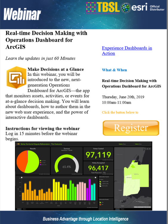
Thursday, June 20th, 2019
10:00am-11:00am
[/fusion_text][/fusion_builder_column][fusion_builder_column type=”1_3″ layout=”1_3″ last=”yes” spacing=”yes” center_content=”no” hide_on_mobile=”no” background_color=”” background_image=”” background_repeat=”no-repeat” background_position=”left top” hover_type=”none” link=”” border_position=”all” border_size=”0px” border_color=”” border_style=”solid” padding_top=”” padding_right=”” padding_bottom=”” padding_left=”” margin_top=”” margin_bottom=”” animation_type=”0″ animation_direction=”down” animation_speed=”0.1″ animation_offset=”” class=”home_events_list” id=”” min_height=””][fusion_title size=”2″ content_align=”left” style_type=”default” sep_color=”” margin_top=”” margin_bottom=”” class=”” id=””]Events[/fusion_title][fusion_text]
Coming soon
[/fusion_text][/fusion_builder_column][/fusion_builder_row][/fusion_builder_container][fusion_builder_container background_color=”” background_image=”” background_parallax=”none” enable_mobile=”no” parallax_speed=”0.3″ background_repeat=”no-repeat” background_position=”left top” video_url=”” video_aspect_ratio=”16:9″ video_webm=”” video_mp4=”” video_ogv=”” video_preview_image=”” overlay_color=”” video_mute=”yes” video_loop=”yes” fade=”no” border_size=”0px” border_color=”” border_style=”solid” padding_top=”20px” padding_bottom=”0px” padding_left=”” padding_right=”” hundred_percent=”no” equal_height_columns=”no” hide_on_mobile=”no” menu_anchor=”” class=”” id=””][fusion_builder_row][fusion_builder_column type=”1_1″ layout=”1_1″ background_position=”left top” background_color=”” border_size=”” border_color=”” border_style=”solid” spacing=”yes” background_image=”” background_repeat=”no-repeat” padding_top=”” padding_right=”” padding_bottom=”” padding_left=”” margin_top=”0px” margin_bottom=”0px” class=”” id=”” animation_type=”” animation_speed=”0.3″ animation_direction=”left” hide_on_mobile=”no” center_content=”no” min_height=”none” last=”no” hover_type=”none” link=”” border_position=”all”][fusion_text]
Esri [fusion_tooltip title=”Keep Updated”]News[/fusion_tooltip]
Stay Current with the latest in Esri News
[/fusion_text][fusion_separator style_type=”double solid” top_margin=”15″ bottom_margin=”10″ sep_color=”” border_size=”” icon=”fa-cogs” icon_circle=”no” icon_circle_color=”#FF9B05″ width=”820px” alignment=”center” class=”” id=”” /][fusion_separator style_type=”none” top_margin=”20px” bottom_margin=”” sep_color=”” border_size=”” icon=”” icon_circle=”” icon_circle_color=”” width=”” alignment=”center” class=”” id=”” /][/fusion_builder_column][fusion_builder_column type=”1_2″ layout=”1_2″ last=”no” spacing=”yes” center_content=”no” hide_on_mobile=”no” background_color=”” background_image=”” background_repeat=”no-repeat” background_position=”left top” hover_type=”none” link=”” border_position=”all” border_size=”0px” border_color=”” border_style=”” padding_top=”” padding_right=”” padding_bottom=”” padding_left=”” margin_top=”” margin_bottom=”” animation_type=”” animation_direction=”” animation_speed=”0.1″ animation_offset=”” class=”” id=”” min_height=””][fusion_separator style_type=”none” top_margin=”40px” bottom_margin=”” sep_color=”” border_size=”” icon=”” icon_circle=”” icon_circle_color=”” width=”” alignment=”center” class=”” id=”” /][fusion_tabs design=”classic” layout=”horizontal” justified=”yes” backgroundcolor=”” inactivecolor=”” bordercolor=”” class=”” id=””][fusion_tab title=”ArcNews” icon=””]Reach more than 750,000 people who are interested in GIS technology through ArcNews, the oldest and largest circulation GIS magazine. In addition to news about the latest developments in GIS and Esri technology, this quarterly publication includes articles that demonstrate how GIS has benefitted users across numerous industries as well as government organizations and scientific research. Special rates available for multiple insertions and Esri partners. Learn More[/fusion_tab][fusion_tab title=”ArcWatch” icon=””]ArcWatch, Your E-Magazine for GIS News, Views, and Insights. Learn More[/fusion_tab][fusion_tab title=”ArcUser” icon=””]ArcUser magazine provides practical, technical information to help you better understand and keep current with GIS technology and make the best use of Esri software. Its articles illustrate best practices and innovative ways to meet new challenges and solve common problems. Articles address the specific needs of GIS managers, GIS developers, GIS technicians, and those who use GIS to improve business processes or perform research. Learn More[/fusion_tab][/fusion_tabs][/fusion_builder_column][fusion_builder_column type=”1_2″ layout=”1_2″ last=”yes” spacing=”yes” center_content=”no” hide_on_mobile=”no” background_color=”” background_image=”” background_repeat=”no-repeat” background_position=”left top” hover_type=”none” link=”” border_position=”all” border_size=”0px” border_color=”” border_style=”” padding_top=”” padding_right=”” padding_bottom=”” padding_left=”” margin_top=”” margin_bottom=”” animation_type=”” animation_direction=”” animation_speed=”0.1″ animation_offset=”” class=”” id=”” min_height=””][fusion_imageframe lightbox=”no” lightbox_image=”” style_type=”none” hover_type=”none” bordercolor=”white” bordersize=”0″ borderradius=”0″ stylecolor=”” align=”center” link=”” linktarget=”_self” animation_type=”slide” animation_direction=”right” animation_speed=”1″ animation_offset=”” hide_on_mobile=”no” class=”image_300″ id=””]  [/fusion_imageframe][/fusion_builder_column][fusion_builder_column type=”1_1″ layout=”1_1″ background_position=”left top” background_color=”” border_size=”” border_color=”” border_style=”solid” spacing=”yes” background_image=”” background_repeat=”no-repeat” padding_top=”” padding_right=”” padding_bottom=”” padding_left=”” margin_top=”0px” margin_bottom=”0px” class=”” id=”” animation_type=”” animation_speed=”0.3″ animation_direction=”left” hide_on_mobile=”no” center_content=”no” min_height=”none” last=”no” hover_type=”none” link=”” border_position=”all”][fusion_separator style_type=”none” top_margin=”” bottom_margin=”20px” sep_color=”” border_size=”” icon=”” icon_circle=”” icon_circle_color=”” width=”” alignment=”center” class=”” id=”” /][/fusion_builder_column][/fusion_builder_row][/fusion_builder_container][fusion_builder_container background_color=”rgba(25,25,25,0.5)” background_image=”http://www.gis.com.bz/wp-content/uploads/2012/07/2016-04-13_13-58-39-1.jpg” background_parallax=”fixed” enable_mobile=”no” parallax_speed=”0.3″ background_repeat=”no-repeat” background_position=”center center” video_url=”” video_aspect_ratio=”16:9″ video_webm=”” video_mp4=”” video_ogv=”” video_preview_image=”” video_mute=”yes” video_loop=”yes” fade=”no” border_size=”1px” border_color=”#e5e4e4″ border_style=”solid” padding_top=”35px” padding_bottom=”45px” padding_left=”” padding_right=”” hundred_percent=”no” equal_height_columns=”no” hide_on_mobile=”no” menu_anchor=”” class=”” id=”” background_blend_mode=”overlay”][fusion_builder_row][fusion_builder_column type=”1_1″ layout=”1_1″ background_position=”left top” background_color=”” border_size=”” border_color=”” border_style=”solid” spacing=”yes” background_image=”” background_repeat=”no-repeat” padding_top=”” padding_right=”” padding_bottom=”” padding_left=”” margin_top=”0px” margin_bottom=”0px” class=”” id=”” animation_type=”” animation_speed=”0.3″ animation_direction=”left” hide_on_mobile=”no” center_content=”no” min_height=”none” last=”no” hover_type=”none” link=”” border_position=”all”][fusion_text]
What Our Clients say About Us?
TBSL is results oriented and focuses on improving efficiency and productivity in the pursuit of strategic objectives.
[/fusion_text][fusion_separator style_type=”none” top_margin=”20″ bottom_margin=”” sep_color=”” border_size=”” icon=”” icon_circle=”” icon_circle_color=”” width=”” alignment=”” class=”” id=”” /][/fusion_builder_column][fusion_builder_column type=”1_3″ layout=”1_3″ last=”no” spacing=”yes” center_content=”no” hide_on_mobile=”no” background_color=”” background_image=”” background_repeat=”no-repeat” background_position=”left top” hover_type=”none” link=”” border_position=”all” border_size=”0px” border_color=”” border_style=”” padding_top=”” padding_right=”” padding_bottom=”” padding_left=”” margin_top=”” margin_bottom=”” animation_type=”” animation_direction=”” animation_speed=”0.1″ animation_offset=”” class=”” id=”” min_height=””][fusion_testimonials design=”classic” backgroundcolor=”” textcolor=”#ffffff” random=”” class=”home_testimonials” id=””][fusion_testimonial name=”Anigie Ramirez, GIS Technician” avatar=”male” image=”” image_border_radius=”” company=”Belize Natural Energy Limited” link=”” target=”_self”]I have been using ArcGIS Desktop for the past five years and every year there is something new to learn about this useful tool. Attending the BEUC not only gives me the opportunity to network and share what I know about ArcGIS, but also gives me the opportunity to learn about new releases such as ArcGIS Pro and attend informative sessions that teach me more on topics such as Geostatistics.[/fusion_testimonial][/fusion_testimonials][/fusion_builder_column][fusion_builder_column type=”1_3″ layout=”1_3″ last=”no” spacing=”yes” center_content=”no” hide_on_mobile=”no” background_color=”” background_image=”” background_repeat=”no-repeat” background_position=”left top” hover_type=”none” link=”” border_position=”all” border_size=”0px” border_color=”” border_style=”” padding_top=”” padding_right=”” padding_bottom=”” padding_left=”” margin_top=”” margin_bottom=”” animation_type=”” animation_direction=”” animation_speed=”0.1″ animation_offset=”” class=”” id=”” min_height=””][fusion_testimonials design=”classic” backgroundcolor=”” textcolor=”#ffffff” random=”” class=”home_testimonials” id=””][fusion_testimonial name=”Anonymous” avatar=”male” image=”” image_border_radius=”” company=”Belize” link=”” target=”_self”]I thoroughly enjoyed today’s webinar. The analysis portion was insightful as I do all of my analysis on desktop and not on AGOL. Thank you![/fusion_testimonial][/fusion_testimonials][/fusion_builder_column][fusion_builder_column type=”1_3″ layout=”1_3″ last=”yes” spacing=”yes” center_content=”no” hide_on_mobile=”no” background_color=”” background_image=”” background_repeat=”no-repeat” background_position=”left top” hover_type=”none” link=”” border_position=”all” border_size=”0px” border_color=”” border_style=”” padding_top=”” padding_right=”” padding_bottom=”” padding_left=”” margin_top=”” margin_bottom=”” animation_type=”” animation_direction=”” animation_speed=”0.1″ animation_offset=”” class=”” id=”” min_height=””][fusion_testimonials design=”classic” backgroundcolor=”” textcolor=”#ffffff” random=”” class=”home_testimonials” id=””][fusion_testimonial name=”Jessamyn” avatar=”female” image=”” image_border_radius=”Belize” company=”” link=”” target=”_self”]Just need to say 3rd Annual GIS User Conference was a success..really enjoyed every moment of it..nice to know GIS is becoming reality in our country..looking forward to upcoming events..kudos TBSL![/fusion_testimonial][/fusion_testimonials][/fusion_builder_column][/fusion_builder_row][/fusion_builder_container][fusion_builder_container hundred_percent=”yes” overflow=”visible” padding_right=”20px” padding_left=”20px”][fusion_builder_row][fusion_builder_column type=”1_1″ layout=”1_1″ background_position=”left top” background_color=”” border_size=”” border_color=”” border_style=”solid” spacing=”yes” background_image=”” background_repeat=”no-repeat” padding_top=”” padding_right=”” padding_bottom=”” padding_left=”” margin_top=”0px” margin_bottom=”0px” class=”” id=”” animation_type=”” animation_speed=”0.3″ animation_direction=”left” hide_on_mobile=”no” center_content=”no” min_height=”none” last=”no” hover_type=”none” link=”” border_position=”all”][fusion_text][widget id=”text-20″][/fusion_text][/fusion_builder_column][/fusion_builder_row][/fusion_builder_container]
 TBSL is an established Belizean IT solutions company that provides high quality and cost-effective business solutions to the corporate market with a management team of 20 years of GIS and business solutions experience combined.