
[fusion_builder_container background_color=”#fff” background_image=”” background_parallax=”none” enable_mobile=”no” parallax_speed=”0.3″ background_repeat=”no-repeat” background_position=”left top” video_url=”” video_aspect_ratio=”16:9″ video_webm=”” video_mp4=”” video_ogv=”” video_preview_image=”” overlay_color=”” overlay_opacity=”0.5″ video_mute=”yes” video_loop=”yes” fade=”no” border_size=”0px” border_color=”#e5e4e4″ border_style=”” padding_top=”15px” padding_bottom=”5px” padding_left=”” padding_right=”” hundred_percent=”no” equal_height_columns=”no” hide_on_mobile=”no” menu_anchor=”” class=”” id=””][fusion_builder_row][fusion_builder_column type=”1_1″ background_position=”left top” background_color=”” border_size=”” border_color=”” border_style=”solid” spacing=”yes” background_image=”” background_repeat=”no-repeat” padding=”” margin_top=”0px” margin_bottom=”0px” class=”” id=”” animation_type=”” animation_speed=”0.3″ animation_direction=”left” hide_on_mobile=”no” center_content=”no” min_height=”none”][fusion_title size=”1″ content_align=”left” style_type=”default” sep_color=”” margin_top=”” margin_bottom=”” class=”” id=””]ArcGIS for Desktop[/fusion_title][/fusion_builder_column][fusion_builder_column type=”1_2″ last=”no” spacing=”yes” center_content=”no” hide_on_mobile=”no” background_color=”” background_image=”” background_repeat=”no-repeat” background_position=”left top” hover_type=”none” link=”” border_position=”all” border_size=”0px” border_color=”” border_style=”” padding=”” margin_top=”” margin_bottom=”” animation_type=”” animation_direction=”” animation_speed=”0.1″ animation_offset=”” class=”” id=””][fusion_text]
[fusion_dropcap]A[/fusion_dropcap]rcGIS for Desktop lets you build maps with up-to-date data, combined with deep analysis, that enables you to share them where they’ll have the most impact.
Overview
People are using ArcGIS in all types of organizations to improve their workflows and solve their most challenging issues.
ArcGIS helps you with:
- Advanced Analysis and Geoprocessing Increase understanding and improve decision-making using powerful modeling and analysis tools.
- Powerful Editing Tools Simplify data design, input, and cleanup with advanced editing capabilities.
- Full Cartographic Production Process Automate many aspects of cartography, making intelligent map production a less time-consuming task.
- >Unlimited Sharing of Data and Maps Easily create and share information with individuals, groups, or organizations.
[/fusion_text][/fusion_builder_column][fusion_builder_column type=”1_2″ last=”yes” spacing=”yes” center_content=”no” hide_on_mobile=”no” background_color=”” background_image=”” background_repeat=”no-repeat” background_position=”left top” hover_type=”none” link=”” border_position=”all” border_size=”0px” border_color=”” border_style=”” padding=”” margin_top=”” margin_bottom=”” animation_type=”” animation_direction=”” animation_speed=”0.1″ animation_offset=”” class=”” id=””][fusion_youtube id=”w6OcAaHZrcY” width=”” height=”” autoplay=”no” api_params=”” class=””/][fusion_separator style_type=”none” top_margin=”50px” bottom_margin=”” sep_color=”” border_size=”” icon=”” icon_circle=”” icon_circle_color=”” width=”” alignment=”center” class=”” id=””/][/fusion_builder_column][/fusion_builder_row][/fusion_builder_container][fusion_builder_container background_color=”#f8f8f8″ background_image=”” background_parallax=”fixed” enable_mobile=”no” parallax_speed=”0.3″ background_repeat=”no-repeat” background_position=”left top” video_url=”” video_aspect_ratio=”16:9″ video_webm=”” video_mp4=”” video_ogv=”” video_preview_image=”” overlay_color=”” overlay_opacity=”0.5″ video_mute=”yes” video_loop=”yes” fade=”no” border_size=”0px” border_color=”” border_style=”” padding_top=”15px” padding_bottom=”5px” padding_left=”” padding_right=”” hundred_percent=”no” equal_height_columns=”no” hide_on_mobile=”no” menu_anchor=”” class=”” id=””][fusion_builder_row][fusion_builder_column type=”1_3″ last=”no” spacing=”yes” center_content=”no” hide_on_mobile=”no” background_color=”” background_image=”” background_repeat=”no-repeat” background_position=”left top” hover_type=”none” link=”” border_position=”all” border_size=”0px” border_color=”” border_style=”” padding=”” margin_top=”” margin_bottom=”” animation_type=”” animation_direction=”” animation_speed=”0.1″ animation_offset=”” class=”” id=””][fusion_title size=”3″ content_align=”center” style_type=”default” sep_color=”” margin_top=”” margin_bottom=”” class=”” id=””]Create Smart Maps and Useful Apps[/fusion_title][fusion_separator style_type=”none” top_margin=”20px” bottom_margin=”” sep_color=”” border_size=”” icon=”” icon_circle=”” icon_circle_color=”” width=”” alignment=”center” class=”” id=””/][fusion_imageframe lightbox=”no” lightbox_image=”” style_type=”none” hover_type=”none” bordercolor=”” bordersize=”0px” borderradius=”0″ stylecolor=”” align=”none” link=”” linktarget=”_self” animation_type=”0″ animation_direction=”down” animation_speed=”0.1″ animation_offset=”” hide_on_mobile=”no” class=”” id=””] 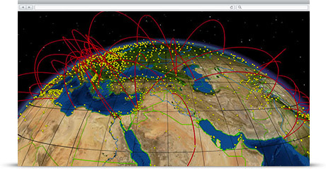 [/fusion_imageframe][fusion_separator style_type=”none” top_margin=”20px” bottom_margin=”” sep_color=”” border_size=”” icon=”” icon_circle=”” icon_circle_color=”” width=”” alignment=”center” class=”” id=””/][fusion_text]
Visualize and share information in new ways for insightful and informed decision making. Map and manage your data with ArcGIS for Desktop, then create apps and share with others via the rest of the ArcGIS platform. ArcGIS for Desktop includes ArcGIS Online, so you immediately have access to a world of relevant content and ready-to-use apps to get you started right away.
[/fusion_text][/fusion_builder_column][fusion_builder_column type=”1_3″ last=”no” spacing=”yes” center_content=”no” hide_on_mobile=”no” background_color=”” background_image=”” background_repeat=”no-repeat” background_position=”left top” hover_type=”none” link=”” border_position=”all” border_size=”0px” border_color=”” border_style=”” padding=”” margin_top=”” margin_bottom=”” animation_type=”” animation_direction=”” animation_speed=”0.1″ animation_offset=”” class=”” id=””][fusion_title size=”3″ content_align=”center” style_type=”default” sep_color=”” margin_top=”” margin_bottom=”” class=”” id=””]Transform Your Data into Actionable Information[/fusion_title][fusion_imageframe lightbox=”no” lightbox_image=”” style_type=”none” hover_type=”none” bordercolor=”” bordersize=”0px” borderradius=”0″ stylecolor=”” align=”none” link=”” linktarget=”_self” animation_type=”0″ animation_direction=”down” animation_speed=”0.1″ animation_offset=”” hide_on_mobile=”no” class=”” id=””] ![]() [/fusion_imageframe][fusion_text]
[/fusion_imageframe][fusion_text]
Create, edit, analyze and share information in powerful and efficient ways. Turn 2D data into 3D for powerful visualization. Easily import and edit data to get at the information you need. Perform analysis to solve your problems. The value-added information you create with ArcGIS for Desktop will transform how decisions are made and results are realized.
[/fusion_text][fusion_separator style_type=”none” top_margin=”20px” bottom_margin=”” sep_color=”” border_size=”” icon=”” icon_circle=”” icon_circle_color=”” width=”” alignment=”center” class=”” id=””/][/fusion_builder_column][fusion_builder_column type=”1_3″ last=”yes” spacing=”yes” center_content=”no” hide_on_mobile=”no” background_color=”” background_image=”” background_repeat=”no-repeat” background_position=”left top” hover_type=”none” link=”” border_position=”all” border_size=”0px” border_color=”” border_style=”” padding=”” margin_top=”” margin_bottom=”” animation_type=”” animation_direction=”” animation_speed=”0.1″ animation_offset=”” class=”” id=””][fusion_title size=”3″ content_align=”center” style_type=”default” sep_color=”” margin_top=”” margin_bottom=”” class=”” id=””]Get the Answers That Your Organization Is Looking for[/fusion_title][fusion_imageframe lightbox=”no” lightbox_image=”” style_type=”none” hover_type=”none” bordercolor=”” bordersize=”0px” borderradius=”0″ stylecolor=”” align=”none” link=”” linktarget=”_self” animation_type=”0″ animation_direction=”down” animation_speed=”0.1″ animation_offset=”” hide_on_mobile=”no” class=”” id=””] 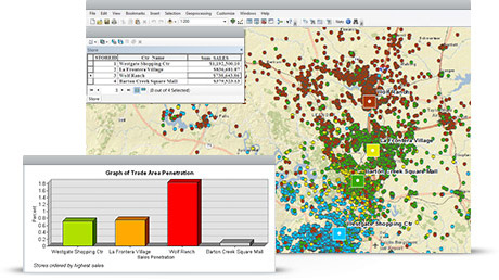 [/fusion_imageframe][fusion_text]
True organizational intelligence comes from looking at the big picture. ArcGIS for Desktop enables you to understand change, identify trends, make predictions, and rank results.
[/fusion_text][fusion_separator style_type=”none” top_margin=”20px” bottom_margin=”” sep_color=”” border_size=”” icon=”” icon_circle=”” icon_circle_color=”” width=”” alignment=”center” class=”” id=””/][/fusion_builder_column][/fusion_builder_row][/fusion_builder_container]
 TBSL is an established Belizean IT solutions company that provides high quality and cost-effective business solutions to the corporate market with a management team of 20 years of GIS and business solutions experience combined.